Image Workshop - Documentation and Download Option(s)
 1921-1930 |
File Identification:Watson-096 | Date Scanned:June 15 2008 | Source of Scanned Image:W.H. Outlaw Jr. | |
| Original Source of Image:Christine W. Outlaw | Digital Archiver:W.H. Outlaw Jr. | Image Restorer: | ||
| Original Image Size: | Scan Resolution (dpi) (Reduced files=200 dpi):- | Exact Date of Original Image: | ||
| Estimated Date of Original Image:1928-1930 | Basis for Date Estimate:(covers a period of time) | Unreduced File Size(px): | ||
| Location:Deep Ditch Community | Background:-- | Activity: | ||
| Unreduced File Size(MB): | Reduced File Size (px): | Reduced File Size (KB):10.5 MB pdf | ||
| Information with Photo: | ||||
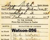
| Subjects:A. Christine Watson (= Christine Watson) report cards for 5th grade and for 6th grade Mark A. Watson (= Mark Watson) signatures ?. S. Weaver, teacher |
||||
| Comments:Note that the teacher misspelled Mama\\\'s name (Chrystine [sic]) on one of the cards. One year was a month longer than the other. The term of the school year was 6 months (though the card was set up for 9 months). So, in those days, a high school diploma was a 66-month program. The children were pretty much available to work in the fields for most of the crop year (March-August). Of course, Mama made an A in deportment. . . . probably all her life was spent trying to please other people. Daddy, Carolyn, and I made up for her a little bit, though. :) A cypress pond/slough lies on the south side of GA 168 just west of the Teeterville Road. To drain this swamp, a 10-feet-deep ditch was dug, heading north toward Buck Bay (the southern boundary of my farm). I don\\\'t know whether the ditch terminated in Buck Bay (= Beaver Dam Drain) or was diverted directly to the Ten-mile Creek (the eastern boundary of my farm). Anyhow, the exact location of Deep Ditch School was on the western edge of the ditch, about 100 yards north of Mud Creek Road (i.e., on the eastern boundary of the mobile-home park now). 31 11 11.1, -83 11 19.8 As I write this, I don\\\'t know when the ditch was dug or when the school was built, but it was already propped up with poles by 1935-6 or thereabouts when Alton Rowan attended. Because of fear that it might fall, the venue was transferred that year to Ruth Forrester Church (the predecessor to the current building). Sheets were hung to partition the church into rooms, and teachers Floy Harrell (or was she Floy Allen by then?) and Abe Sirmons (principal) continued the task of educating their charges. Supplemental A is a sketch of the school made by Alton Rowan. About 80 ft long, it faced Mark Watson Road and it sat just on the western edge of the ditch, so close that when it leaned eastward the supporting poles were anchored on the eastern side of the ditch. The exterior was made of clapboard (not logs, to the best of Alton\\\'s memory). It was not sealed, i.e., the rooms had no ceiling, so they were open to the underside of the roof. The school was divided into 2-3 rooms. To the northern side of the school was an outhouse for boys. Presumably the outhouse for girls was on the southside. A small roofed structure with cubby holes for lunches was in front of the school. mfr who 2012-12-14 efile 96c: Alton drawing sketch. Supplemental B is an image of the Deep Ditch taken in 2012 from the northern edge of Hiway 168. Mama discussed Deep Ditch School extensively. See her Recollections, Outlaw-441. P.S. In her \\\"Recollections,\\\" Mama puts the date of consolidation of Deep Ditch School with the Nashville School District at 1933 which is in error. Not a substantive error, however. Last edit: 2012-12-14 |
||||
| Download Supplemental Image A | Download Reduced Image (Original Image can be supplied upon request.) |
Download Supplemental Image B | ||